
Places to Walk in Trinidad: Mt St Benedict/Mt Tabor
I only just realised I haven't blogged about this route despite having done it a couple times before.
Y'all know I'm always game for an adventure and Mt Tabor was actually my first ever attempt at climbing a mountain. I did it for the first time in June, 2016 at my heaviest weight of over 220 pounds and almost died.
I did it again some months later just to see if my fitness level had improved.
However, the route taken on those occasions was completely different and much more difficult. Most people going up Mt Tabor usually take the route walking along the roadway from the bottom of St John's road in St Augustine, past the Mt St Benedict Abbey.
My previous experiences with Mt Tabor was actually starting from the foot of the mountain itself and literally climbing the steep slopes with nothing other than trees and bushes to hold on to to pull myself upwards.
You can read about that experience here.
The easier and more popular route is what I did these past couple weeks. Mostly because we all know Trinidad has gone to shit with crime and it is probably safer to walk along a public roadway than through a forest.
Anyway, I compare every route to Chancellor Hill because Chancellor Hill is what I'm most accustomed to walking and what I am most familiar with. So St John's Road, I would say, is equivalent to Chancellor Hill in terms of distance and difficulty. About 2.2 miles to the end of the road.
Once you get to the end of the road however, that's when the real bacchanal begins.
The road ends at an abandoned building just around the corner from a drug rehabilitation centre.
The road ends there but a trail begins, which can be followed to get to the top of Mt Tabor or what is commonly referred to as "The Pines", because of the pine trees that grow at the top.
The trail is not for the faint of heart. It is steep, rugged, rocky, and did I mention steep?
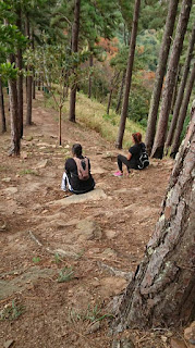
This morning I ventured up with two friends and the route was pretty busy with other joggers and walkers.
I ain't gonna lie, I ketch my ass.
There were other hikers on the trail and they ketch dey ass too. Literally every few steps we had to sit and rest. And by "we" I mean me and Kitty. My other friend, Raquel, scaled the mountain like a pro and barely broke a sweat!
Anyway, from the start of the trail to the top of the mountain is a little over half a mile. Not a lot, but it feels like a lot.
Along the trail you will pass a fire tower used by forest rangers to observe bush fires. It's a treat to climb to the top of the tower (although there is a no trespassing sign). The view is magnificent from up there though and everything looks like ants below.


Eventually we got to the top where loads of selfies were taken to commemorate our achievement. There is a trail that continues to the right which a hiking couple told us leads back down to St John's village. So the route can be done as a loop. We declined, and went back the way we came up.


The trek back down was easy, naturally. I climbed the tower to see what there was to see. My two friends declined to breach the "no trespassing" sign. What law-abiding citizens they are! Lol.
On the way down, rain started falling heavily, we got soaked but didn't mind at all.
The entire trek was just under 6 miles overall and took 3 hours and 49 minutes. (Although the Relive app has the wrong time. I don't know why it does that).

Length: 9.3km total (5.8 miles) from the bottom of St John's Road
Terrain: Paved road leading to dirt trail
Time: About 1 hr 45 minutes minutes one way, walking at a moderate pace and stopping for REGULAR breaks.
A normal person would probably do it in an hour. lol
Got any ideas of scenic places to walk or hike to? Comment any suggestions down below!
Y'all know I'm always game for an adventure and Mt Tabor was actually my first ever attempt at climbing a mountain. I did it for the first time in June, 2016 at my heaviest weight of over 220 pounds and almost died.
I did it again some months later just to see if my fitness level had improved.
However, the route taken on those occasions was completely different and much more difficult. Most people going up Mt Tabor usually take the route walking along the roadway from the bottom of St John's road in St Augustine, past the Mt St Benedict Abbey.
My previous experiences with Mt Tabor was actually starting from the foot of the mountain itself and literally climbing the steep slopes with nothing other than trees and bushes to hold on to to pull myself upwards.
You can read about that experience here.
The easier and more popular route is what I did these past couple weeks. Mostly because we all know Trinidad has gone to shit with crime and it is probably safer to walk along a public roadway than through a forest.
Anyway, I compare every route to Chancellor Hill because Chancellor Hill is what I'm most accustomed to walking and what I am most familiar with. So St John's Road, I would say, is equivalent to Chancellor Hill in terms of distance and difficulty. About 2.2 miles to the end of the road.
Once you get to the end of the road however, that's when the real bacchanal begins.
The road ends at an abandoned building just around the corner from a drug rehabilitation centre.
The road ends there but a trail begins, which can be followed to get to the top of Mt Tabor or what is commonly referred to as "The Pines", because of the pine trees that grow at the top.
The trail is not for the faint of heart. It is steep, rugged, rocky, and did I mention steep?
This morning I ventured up with two friends and the route was pretty busy with other joggers and walkers.
I ain't gonna lie, I ketch my ass.
There were other hikers on the trail and they ketch dey ass too. Literally every few steps we had to sit and rest. And by "we" I mean me and Kitty. My other friend, Raquel, scaled the mountain like a pro and barely broke a sweat!

Along the trail you will pass a fire tower used by forest rangers to observe bush fires. It's a treat to climb to the top of the tower (although there is a no trespassing sign). The view is magnificent from up there though and everything looks like ants below.


Eventually we got to the top where loads of selfies were taken to commemorate our achievement. There is a trail that continues to the right which a hiking couple told us leads back down to St John's village. So the route can be done as a loop. We declined, and went back the way we came up.


The trek back down was easy, naturally. I climbed the tower to see what there was to see. My two friends declined to breach the "no trespassing" sign. What law-abiding citizens they are! Lol.
On the way down, rain started falling heavily, we got soaked but didn't mind at all.
The entire trek was just under 6 miles overall and took 3 hours and 49 minutes. (Although the Relive app has the wrong time. I don't know why it does that).

Length: 9.3km total (5.8 miles) from the bottom of St John's Road
Terrain: Paved road leading to dirt trail
Time: About 1 hr 45 minutes minutes one way, walking at a moderate pace and stopping for REGULAR breaks.
A normal person would probably do it in an hour. lol
Got any ideas of scenic places to walk or hike to? Comment any suggestions down below!


Comments
Post a Comment