Places to hike in Trinidad: Rio Seco Waterfall
The first hike I ever did was to Rio Seco Waterfall. It's the hike that made me a hiker and fuelled a passion for the bush. And it remains my favorite hike to date. I've only been back a couple times since the first time because it's just so goddamn far. But today I decided to go back to where it all began.
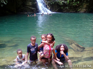
Rio Seco Waterfall usually has one of the most pristine plunge pools at its base. Blue green water, so clear you can see fish swimming at the bottom. Picture a swimming pool deep in the forest. That's why I fell in love with this hike.
These photos are from when I hiked there in April, last year.


What I saw today was disappointing. Apparently there was heavy rain the day before and the water was brown and murky. Nothing like the Rio Seco I know and love. When ah tell yuh ah coulda cry! I know now to visit in the dry season. This was Rio Seco today.
Despite the disappointment of the murky pool, I enjoyed the trek to get there. It was exactly as I remembered.
To get to Rio Seco Waterfall, you drive along the Toco Main Road until you get to the village of Salybia. The turnoff to get to the waterfall is directly opposite Salybia beach. It's very easy to miss. I remember a huge sign being there last year but the sign is now corroded to the point of being almost useless.
From the main road to the start of the hike trail is about 2.6 km.
You can park in the clearing at the end of the road.
Be careful with parking though. There have been incidents of people breaking into hikers' vehicles at this location in the past.
The trail isn't as well-maintained as it used to be. The signs are faded, the trail is blocked by fallen trees, many parts are overgrown.
In fact we came across a hiking couple who had somehow wandered off the trail and ended up trekking through the river hoping to find their way again. We saw them in the distance and shouted out to them that they were going the wrong way and got them back on the path.
It takes about 35 minutes to get to the waterfall. There are some steep inclines and much of the trail is bordered on one side by a steep precipice. That aside, the Rio Seco trail is one of the easiest ones to do, once you're careful.
Visit in the dry season to see the waterfall at its most attractive.
From the start of the trail to the waterfall is 1.1 miles so the return trek came up to 2.2 miles. Just about one lap of the Queen's Park Savannah.
But I walked back out from the trailhead to the main road and lengthened the trek to almost 4 miles.
I had intended to visit the Rampanalgas waterfall as well, which is also in the area but time did not allow it.
Actually, there are a number of awesome hikes in this area including my 4th favorite Mermaid Pool and my 2nd favorite La Foret Bay.
If you're gonna drive all the way to Matura/Salybia/Toco, you might as well get as many hikes in as possible right?
We couldn't do another one today but we still managed to act like tourists and go see the Toco lighthouse.
Not gonna lie, it was underwhelming. Dilapidated looking and cordoned off with caution tape. The surrounding area was vandalised and dirty. Me inno how this thing is a tourist attraction, oui.


(Walking back out to Toco Main Road took me about another 25 minutes.)
Level: Rated level 3
Got any ideas of scenic places to walk or hike to? Comment any suggestions down below!
Rio Seco Waterfall usually has one of the most pristine plunge pools at its base. Blue green water, so clear you can see fish swimming at the bottom. Picture a swimming pool deep in the forest. That's why I fell in love with this hike.
These photos are from when I hiked there in April, last year.


What I saw today was disappointing. Apparently there was heavy rain the day before and the water was brown and murky. Nothing like the Rio Seco I know and love. When ah tell yuh ah coulda cry! I know now to visit in the dry season. This was Rio Seco today.
Despite the disappointment of the murky pool, I enjoyed the trek to get there. It was exactly as I remembered.
To get to Rio Seco Waterfall, you drive along the Toco Main Road until you get to the village of Salybia. The turnoff to get to the waterfall is directly opposite Salybia beach. It's very easy to miss. I remember a huge sign being there last year but the sign is now corroded to the point of being almost useless.
From the main road to the start of the hike trail is about 2.6 km.
You can park in the clearing at the end of the road.
Be careful with parking though. There have been incidents of people breaking into hikers' vehicles at this location in the past.
The trail isn't as well-maintained as it used to be. The signs are faded, the trail is blocked by fallen trees, many parts are overgrown.
In fact we came across a hiking couple who had somehow wandered off the trail and ended up trekking through the river hoping to find their way again. We saw them in the distance and shouted out to them that they were going the wrong way and got them back on the path.
It takes about 35 minutes to get to the waterfall. There are some steep inclines and much of the trail is bordered on one side by a steep precipice. That aside, the Rio Seco trail is one of the easiest ones to do, once you're careful.
Visit in the dry season to see the waterfall at its most attractive.
From the start of the trail to the waterfall is 1.1 miles so the return trek came up to 2.2 miles. Just about one lap of the Queen's Park Savannah.
But I walked back out from the trailhead to the main road and lengthened the trek to almost 4 miles.
I had intended to visit the Rampanalgas waterfall as well, which is also in the area but time did not allow it.
Actually, there are a number of awesome hikes in this area including my 4th favorite Mermaid Pool and my 2nd favorite La Foret Bay.
If you're gonna drive all the way to Matura/Salybia/Toco, you might as well get as many hikes in as possible right?
We couldn't do another one today but we still managed to act like tourists and go see the Toco lighthouse.
Not gonna lie, it was underwhelming. Dilapidated looking and cordoned off with caution tape. The surrounding area was vandalised and dirty. Me inno how this thing is a tourist attraction, oui.


Length: The trail itself - 2.2 miles (3.5 km) return trek
Including walk back out to Toco Main Road - 3.86 miles (6.2 km)
Terrain: Uneven pitch road leading to muddy dirt trail
Time: 35 - 40 minutes one way(Walking back out to Toco Main Road took me about another 25 minutes.)
Level: Rated level 3
Got any ideas of scenic places to walk or hike to? Comment any suggestions down below!


Comments
Post a Comment